")
")
GeoLinked Data
The information in this page is deprecated. We will soon update it with the new developments in geographical Linked Data that we are doing together with the Instituto Geográfico Nacional. For the time being, a richer description is available in the Spanish version
GeoLinked Data (.es) is an open initiative aimed at enriching the Data Web with geospatial data taken form the Spanish national territory. This initiative started by publishing different geographical information sources and then making the sources available as RDF knowledge bases (Resource Description Framework), following the principles of Linked Data. These data are interrelated with other knowledge databases of the Linking Open Data initiative. Thus, Spain supports this initiative, which is also supported by countries such the United Kingdom and Germany.
The geospatial information sources published are from the Spanish National Geographic Institute (IGN by its Spanish acronym) and from the National Centre of Geographic Information (CNIG by its Spanish acronym). Both sources collect multiple and varied information at different scales in the different official languages of the country (Castilian, Catalan, Basque, Galician, and Aranese).
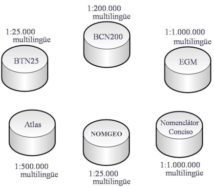
A general overview of the published sources appears in the figure above. For further information, please, refer to the Sources of Data.
GeoLinked data uses R2O and ODEMaster as supporting technology for transforming relational databases into RDF knowledge bases. This integrated framework is used for the formal expression, evaluation, verification and exploitation of semantic mappings betweenontologies and relational databases.
To get access to the information published in GeoLinked Data, please read the information available via SPARQL Endpoint.
For further information, please consult the portal web of GeoLinked Data.
